
In short
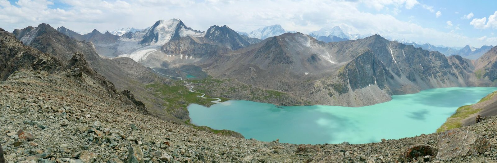
Karakol is 400 km and 6–7 hours from Bishkek. The Ala-Kul trek runs 40–55 km over 2–4 days to a lake at 3,532 m, and the reliable snow-free window is mid-July to mid-September — park entry 300 som. No border permit is needed for any Karakol trek. In town, the Sunday animal market runs 07:00–11:00 and the Dungan Mosque costs 20 som.
Trek data from Karakol’s destination management organisation; all figures checked 26 August 2026.
On this page
Karakol is the base for the best trekking in Kyrgyzstan, and the town itself holds a wooden Orthodox cathedral and a Chinese-built mosque assembled without a single nail.
It also sits beside a lake 668 metres deep that almost never freezes. Here is what to do from here, and an honest account of the Ala-Kul pass, where the sources genuinely disagree about whether you need a guide.
Issyk-Kul, in numbers
| Surface area | 6,236 km² |
| Maximum depth | 668 m |
| Altitude | 1,607 m |
| Dimensions | 182 km long, up to 60 km wide |
| Salinity | About 0.6% — roughly a sixth of seawater |
The name means “warm lake,” and it earns it: the mild salinity keeps it from freezing. It is a Ramsar site and has been part of UNESCO’s World Network of Biosphere Reserves since 2000. Its level is currently falling about five centimetres a year through water diversion.
North shore or south? The north is the developed side — the “Kyrgyz Riviera,” with beach resorts around Cholpon-Ata, the petroglyph field, and family recreation. The south is quieter and wilder: red canyons, the Skazka “fairytale” canyon, eagle hunters and felt workshops at Bokonbaevo, and summer pastures where shepherds still live in yurts.
For a traveller with limited time, the south is more interesting and the north is more convenient. Tourism here has tripled since 2019 — the region’s guesthouse count went from 627 in 2019 to 1,833 in 2025 — so “quiet” is relative and shrinking.
Karakol town
The Dungan Mosque was built between 1907 and 1910, completed on 10 May 1910. A designer invited from China — recorded as Chou-si — directed thirty craftsmen, and the building went up without nails or metal fixings of any kind, assembled from poplar and elm beams with special axes. The main structure came through the Soviet period intact; the minaret was lost in the 1930s and rebuilt in the 1940s.
Open daily 08:00–18:00, admission 20 som, which supports the mosque foundation and may rise in high season. Women must cover arms, legs and head — hooded coats are provided at the door.
The Holy Trinity Cathedral has had a harder century. A garrison chapel from 1869 was destroyed by an earthquake in 1889. The present wooden church was built in 1894–95 by the Maslikov family to designs from Verny, now Almaty, standing about 26 metres to the cross — then the tallest thing in town. After 1917 it served as a school, a sports hall, a theatre and a coal store, had a brief religious revival in 1947, was secularised again in 1961 and abandoned in 1982. Restoration began in 1986 and it returned to the Orthodox community after independence.
Open Monday to Saturday 08:00–18:00, Sunday 08:00–17:00, free. Scarves are provided.
The Sunday animal market — Mal Bazaar — runs 07:00 to 11:00 and winds down towards ten, on the edge of town about 2 km north. Marshrutka #101 costs 20 som; a Yandex taxi from 70. Visitors are explicitly welcome, and the town’s own tourism body recommends sturdy footwear, because you will be standing among horses, cattle, sheep and donkeys. Go as early as you can.
Also worth an hour: the Przhevalsky Museum, daily 09:00–17:00 from 100 som, about fifteen minutes out of town; and the Karakol History Museum, weekdays 09:00–17:00 and weekends 10:00–16:00, from 70 som for foreigners, with a free audio guide in English and French.
Karakol’s Dungan community — Hui Muslims who fled China in the nineteenth century — also gave the town its food. Ashlyamfu, a cold, sour, spicy noodle and starch-jelly dish, is the local speciality and is served all over town.
The treks, with official numbers
These come from Karakol’s own destination management organisation, which is the most institutional trek data available for the country.
| Trek | Distance | Days | Altitude | Season |
|---|---|---|---|---|
| Ak-Suu Arboretum | 13 km | 1 | 1,902–2,464 m | Year-round |
| Kok-Jar – Altyn Arashan | 18 km | 2 | 2,278–3,627 m | June–October |
| Archa-Tor Pass | 33 km | 3 | 2,035–3,980 m | June–October |
| Boz-Uchuk Lakes | 63 km | 3 | 2,128–3,478 m | June–September |
| Highlights of Ak-Suu | 65 km | 5 | 1,900–3,907 m | July–October |
| Ak-Suu Traverse | 110 km | 8 | 1,800–3,980 m | July–September |
Note the Archa-Tor entry carries an explicit warning of avalanche and rockfall hazard until mid-July — the closest thing to an institutional snow warning anywhere in Kyrgyz trekking material, and it applies to comparable altitudes elsewhere.
Ala-Kul: the honest version
The lake is at 3,532 metres, the route runs 40–55 km over two to four days, and it is rated moderate to hard. Four days is the comfortable independent version.
The pass altitude is genuinely disputed — current sources put it anywhere between 3,860 and 3,920 m. Nobody seems certain.
Snow. The reliable window is mid-July to mid-September. Snow can remain on the pass into mid-July and returns by October. But do not read that as a guarantee: one trekker hit a whiteout at the pass in June with sub-zero temperatures and ice held on north-facing slopes while south-facing ones were bare, and another reported stretches of snow, nonstop rain and severe cold in mid-August.
The hazards that recur across every account: loose scree near and below the pass, a steep and very loose descent, mud when wet, and weather that turns in minutes. Altitude sickness is repeatedly flagged near 4,000 m — spend a night or two in Karakol at 1,700 m first.
Do you need a guide? The sources disagree, and we are not going to pretend otherwise.
Against: most people do it unguided, the trail is popular enough that you will rarely go half an hour without meeting someone, and several experienced hikers describe doing it solo with offline maps.
For: guides are recommended for anyone with limited experience, because the route becomes difficult when snow-covered or when visibility drops.
The synthesis we would stand behind: a fit, experienced hiker in late July or August, with a forecast, can do this unguided and most do. Early in the season, or in snow, or in poor visibility, every source that has actually been up there in bad conditions converges on the same advice — get local information, and consider a guide.
Costs on the trail: Karakol National Park entry is 300 som. Yurt camps on the route run 3,000–3,500 som per person including dinner and breakfast. There is a reported 1,000 som river crossing charge on the second day. Wild camping is permitted.
Getting to the trailhead: marshrutka #101 to the park entrance for 30 som, then a shared jeep to the first bridge for around 250 som per person, or a taxi to the Second Bridge for about 2,000 som.
Altyn-Arashan
The hot-springs valley is 16 km from Ak-Suu village near Karakol, and the road is rocky, steep and genuinely only passable in a proper off-road vehicle — the old Russian UAZ vans that do this run take 1.5 to 2 hours.
Prices split sharply. A commercial transfer is quoted at US$140 one way per vehicle for up to six people, US$170 for a next-day return. Independent travellers report US$75–100 with a private driver, or a taxi to Ak-Suu for 8,000 som for up to four. You can also just walk in, which many do, coming out by bus #350 for about 30 som.
Staying: a hostel bed around 1,500 som, yurts 3,500–4,500 som. One guesthouse charges 50 som to camp or 2,800 som for a full package with meals and hot-springs access. The springs themselves are 250 som per person. Wi-Fi, where it exists, is 100–200 som.
Jeti-Ögüz
Twenty-eight kilometres west of Karakol, and the easiest good day out. Marshrutka #372 or a shared taxi from Ak-Tilek Bazaar costs 100 som, running every thirty minutes between 07:00 and 18:30, later in summer. A private taxi is 1,500–2,000 som one way.
The standard outing is a three-hour hike to the Kok-Jayik “Girl’s Braids” waterfall through a flower valley. No 4WD needed and no entrance fee listed. Leave Karakol between seven and nine. The Seven Bulls and Broken Heart red rock formations are at the valley mouth on the way in.
Winter, briefly
Karakol Ski Base ran 27 November to 31 March for the 2025/26 season. A day pass was 1,400 som midweek and 1,700 som Friday to Monday, with children under twelve at 1,000 and night skiing at 1,000. The mountain runs from 2,300 to 3,040 m — 740 m of vertical and about 20 km of pistes — 13 km from town, roughly 20 minutes and 3,000 som by taxi return.
It matters even for summer visitors: the ski industry is why a town this size has guesthouses, gear rental and year-round infrastructure.
Permits and beds
None of the Karakol treks requires a border-zone permit. Ala-Kul, Altyn-Arashan and Jeti-Ögüz are all outside the regulated zones. That is not true elsewhere in the country — see our guide to Kyrgyz border-zone permits before planning Kel-Suu or Peak Lenin.
Karakol has an unusually good hostel scene for its size, with dorms from about US$8 and several places rating above 9 out of 10. Mid-range guesthouses run roughly US$25–50 a double.
Getting here
From Bishkek it is 400 km and six to seven hours. Marshrutkas from about 500 som, shared taxis 1,000–1,500 som in five to six hours, and overnight GoBus services at 21:00, 22:00 and 23:00 from around 500 som.
There is also a seasonal train from Bishkek to Balykchy at the western end of the lake, running daily from late June to mid-September — four hours for 180 som. It is barely mentioned in English and it is a lovely way to arrive.
What we could not verify
The Ala-Kul pass altitude, where reputable sources differ by 60 metres. Whether the reported river-crossing charge is standard or opportunistic. And current prices for most Karakol restaurants — we have deliberately not named places we could not confirm are still open.
For planning the whole trip, see our Kyrgyzstan travel guide; for the yurt-stay end of it, Song-Köl.
Photo: Lake Ala Kul Trek (Kyrgyzstan, August 2019) – 63 (50565167883) by Bruno Rijsman, via Wikimedia Commons, CC BY-SA 2.0.